Cart is empty
- Menu
- IITMS
- ITMS
-
Fintech Solutions
- Automatic Fare Collection (AFC) System for Smart Public Transport
- Payment Gateway Aggregator Platform for Secure & Scalable Digital Payments
- Wallet Payment Gateway Platform for Secure Digital Wallet Payments
- Loan Management System (LMS) for Digital Lending & EMI Management
- Fixed Deposit Management System for Smart & Secure FD Operations
- Loyalty
- Event Management
-
RouteSync
- DrivePro - Driver Management for Public Transport Systems
- ConductorPro - Bus Conductor Management for Public Transport Systems
- DepotMaster - Bus Depot Management for Public Transport Systems
- BusAssignPro - Bus Allocation Management for Public Transport Systems
- RouteGenius - Intelligent Bus Route Generator for Public Transport Systems
- ScheduleSmart - Bus Trip Scheduler and Timetable Generator for Public Transport Systems
- TransitFinancePro - Accounting, Reporting & Analytics for Public Transport Systems
- TransitExpert - Survey and Consultancy Services for Public Transport Systems
- TransitAppPro - Mobile Applications and APIs for Public Transport Systems
- ParkFinder - Smart Parking Solutions
- FlightPulse - Instant Flight Arrival & Departure Information
- RailCompass - Real-time Train Information Solutions
- View more →
- Softwares
- Website Solutions
- Server Management Services
- Remote Developers

- Menu
- IITMS
- ITMS
-
Fintech Solutions
- Automatic Fare Collection (AFC) System for Smart Public Transport
- Payment Gateway Aggregator Platform for Secure & Scalable Digital Payments
- Wallet Payment Gateway Platform for Secure Digital Wallet Payments
- Loan Management System (LMS) for Digital Lending & EMI Management
- Fixed Deposit Management System for Smart & Secure FD Operations
- Loyalty
- Event Management
-
RouteSync
- DrivePro - Driver Management for Public Transport Systems
- ConductorPro - Bus Conductor Management for Public Transport Systems
- DepotMaster - Bus Depot Management for Public Transport Systems
- BusAssignPro - Bus Allocation Management for Public Transport Systems
- RouteGenius - Intelligent Bus Route Generator for Public Transport Systems
- ScheduleSmart - Bus Trip Scheduler and Timetable Generator for Public Transport Systems
- TransitFinancePro - Accounting, Reporting & Analytics for Public Transport Systems
- TransitExpert - Survey and Consultancy Services for Public Transport Systems
- TransitAppPro - Mobile Applications and APIs for Public Transport Systems
- ParkFinder - Smart Parking Solutions
- FlightPulse - Instant Flight Arrival & Departure Information
- RailCompass - Real-time Train Information Solutions
- View more →
- Softwares
- Website Solutions
- Server Management Services
- Remote Developers
Home/Intelligent Integrated Transport Management System (IITMS)/Route Rationalization for Efficient Public Transport Planning.
Route Rationalization for Efficient Public Transport Planning.
Optimize your transport network with our Route Rationalization service. Designed for governments, transit authorities, schools, and enterprises, this solution uses AI, GIS, and real-time data to improve route efficiency, reduce operational costs, and enhance commuter experience.
Contact usWHO BENEFITS FROM ROUTE RATIONALIZATION?

Government

Enterprise
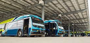
Transit Agencies

School

College

Police
 Existing Routes
Analyze and refine current routes using performance data, commuter density, and peak time behavior to eliminate redundancies and improve coverage.
 Expansion Routes
Identify high-potential growth corridors with demand forecasting, enabling smart expansion to serve emerging residential, educational, and commercial zones.
 New Routes
Design fresh routes with zero guesswork — using geospatial heatmaps, traffic flow patterns, and travel time simulations to ensure optimal placement and ridership.
Route Audit —
Evaluate What Exists Before Planning Ahead
- Review current routes for inefficiencies, overlaps, and gaps.
- Analyze ridership trends, load factors, and stop frequency.
- Benchmark service coverage against demand zones.
Demand Mapping —
Understand Where People Need to Go
- Use heatmaps to locate population clusters and trip demand.
- Match educational institutions, offices, markets with transport needs.
- Predict future demand using AI and seasonal trends.
Planning & Simulation —
Build Smarter Routes, Virtually
- Test multiple route scenarios before deployment.
- Simulate traffic loads, stops, travel time and rider experience.
- Optimize for cost-efficiency, frequency, and speed.
Live Monitoring —
Track Routes & Respond in Real-Time
- Monitor buses, shuttles, and drivers live via GPS integration.
- Receive alerts for deviations, delays, and bottlenecks.
- Visual dashboards for daily operational tracking.

Stakeholder Dashboard —
Empower All Involved
- Custom portals for government, school, or enterprise clients.
- Control route changes, monitor performance, and generate reports.
- Secure role-based access across teams.
System Integration —
Plug Into What You Already Use
- Integrate with fleet GPS, ticketing, HR, and finance systems.
- REST APIs for data exchange with third-party platforms.
- Minimal disruption, maximum compatibility.
What is Route Rationalization?
Route Rationalization is the strategic redesign of transport routes to match current and future travel demand. It reduces inefficiencies, enhances accessibility, and improves operational performance across all transit types including school buses, city transport, and emergency services.

Why Choose Our System?
Our intelligent system leverages real-time data, GIS mapping, and AI simulations to offer predictive insights. Whether you're optimizing a fleet of public buses or planning a college shuttle system, we help you reduce cost and increase rider satisfaction.

Key Functionalities
- Data-Driven Route Analysis & Redesign
- Service Frequency Optimization
- First-Mile/Last-Mile Integration
- Multi-modal Transit Planning
- Scenario Simulation & Forecasting

Custom Solutions for Every Sector
Our platform adapts to various sector needs: GPS-tracked school routes, optimized emergency vehicle dispatch, or commuter rail integrations. We offer fully customized dashboards and reporting for stakeholders at every level.

Seamless Integration
Integrate with your existing ticketing, fleet tracking, and incident response systems using our API-first platform. We ensure minimal disruption while maximizing impact on operations and policy formulation.

1631
Our Offices
India
Salasar ecommerce total solutions pvt ltd
235, Old-Bagadganj Layout, Shastri Nagar Chowk,
Nagpur-440008. Mahrashtra, India
Singapore
M&R Business solutions PTE ltd
2 Gambas crescent. #06-30, Nordcom two,
singapore 757044
 Facebook
 Instagram
 LinkedIn
 YouTube
© Copyright 2014-2026, ArenaSoftwares (Registered in India/Singapore). All rights reserved.
Arenasoftwares doesn't authorize any third party sellers to re-sell Arenasoftwares modules.
Arenasoftwares doesn't authorize any third party sellers to re-sell Arenasoftwares modules.